| |
|
Northern Coastal Area and
Adriatic Sea
|
|

|
|
View # 2
|
View # 3
|
|
Photo Number:
|
STS036-152-237
|
|
Date / Time:
|
March 1990 / 089:59:15
|
|
Geographic Region:
|
Italy, Slovenia, Croatia
|
|
Feature:
|
Northern Coastal Area and Adriatic Sea
|
|
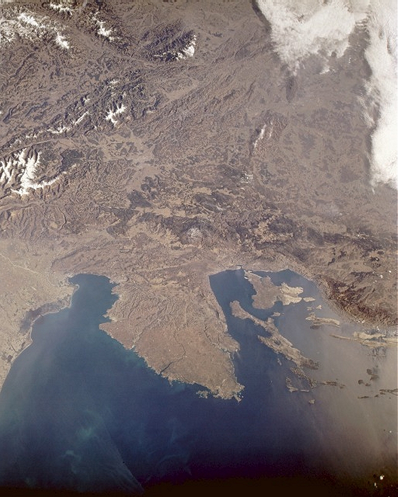
The rough, hilly terrain and low mountains northeast of the Adriatic Sea are
evident in this low-oblique, northeast-looking photograph. The eastern
boundary of the Alps, shown along the western margin of the photograph, ends
in northeastern Italy and northwestern Slovenia. The Istria Peninsula, the
very large land mass extending southward into the Adriatic Sea, is bordered
on the west by the Gulf of Venice (and the smaller Gulf of Trieste) and on
the east by the Gulf of Kvarner. The boundaries of northeastern Italy
(including the city of Trieste), Slovenia, and Croatia and the capital
cities of Ljubljana (Slovenia) and Zagreb (Croatia) are not discernible at
this scale. The offshore islands southeast of the peninsula belong to
Croatia. Slovenia is almost land locked, except for a small corridor that
extends between Italy and Croatia along the northwest coast of the Istria
Peninsula. Many of the mountains contain dense forests (dark areas), whereas
the mountain valleys appear light green and tan. Part of the coastal plain
of northeastern Italy is visible along the western margin of the photograph.
See also: Where
is Istria? |
Technical Notes
|
Images: |
Hi-Resolution
5.31
Mb
Lo-Resolution
100 Kb |
|
Mission: |
STS036
|
|
Roll - Frame: |
152 -
237
|
|
Geographical Name: |
SLOVENIA
|
|
Center Lat x Lon: |
45.5N x 14.5E
|
|
Film Exposure: |
N
|
N=Normal exposure, U=Under exposed, O=Over exposed, F=out of Focus
|
Percentage of
Cloud Cover-CLDP: |
10
|
-
|
|
Camera Tilt: |
NV
|
LO=Low Oblique, HO=High Oblique, NV=Near Vertical
|
|
Camera Focal Lenth: |
90
|
-
|
|
Camera Look Direction: |
E
|
The direction from the nadir to the center point, N=North, S=South, E=East,
W=West
|
|
Stereo?: |
Y
|
Y=Yes there is an adjacent picture of the same area, N=No there isn't
|
|
Orbit Number: |
66
|
-
|
|
Date: |
19900304
|
YYYYMMDD
|
|
Time: |
085915
|
GMT HHMMSS
|
|
Nadir Lat: |
45.4N
|
-
|
|
Nadir Lon: |
E
|
-
|
|
Sun Azimuth: |
140
|
Clockwise angle in degrees from north to the sun measured at the nadir point
|
|
Space Craft Altitude: |
115
|
nautical miles
|
|
Sun Elevation: |
30
|
Angle in degrees between the horizon and the sun, measured at the nadir
point
|
|
Land Views: |
PENINSULA, COAST, ISLAND, MOUNTAIN, VALLEY
|
|
Water Views: |
BAY, RIVER
|
|
Atmosphere Views: |
-
|
|
Man Made Views: |
-
|
|
City Views: |
-
|
Source:
-
Image source (low resolution) -
https://earth.jsc.nasa.gov/lores.cgi?PHOTO=STS036-152-237
-
NASA JSC Digital Image Collection - Earth from Space -
https://earth.jsc.nasa.gov/photoinfo.cgi?PHOTO=STS036-152-237
|
Main Menu
Created: Saturday, June
09, 2001; Last updated:
Saturday, December 03, 2022
Copyright © 1998
IstriaNet.org, USA |
|