|

Karst Landscapes
Bare
Karst | Covered Karst |
Doline or Sink | Dry Valley |
Karren |
Karst Cave |
Karst Lake |
Karst Spring | Losing Stream
| Natural Bridge |
Polje | Ponor | Speleothems
| Tower Karst | Vorfluter
From Treccano
Enciclopedia Italiana:
Carso: Regione compresa, in
senso stretto, nelle Alpi Giulie; secondo un’accezione più ampia si
estende, discontinuamente, tra queste e le Alpi Dinariche, dalla
Carinzia al Montenegro, articolandosi in varie subregioni, che
ricadono in territorio italiano (C. Monfalconese, C. Tiestino ),
sloveno (Alto C., C. Carniolino), croato (C. Istriano, C. Dalmata),
bosniaco e montenegrino. Le forme tipiche sono quelle di altopiani
brulli per la quasi assenza di circolazione idrica superficiale, ma
intercalati a depressioni dove l’accumulo di residui insolubili e
poco permeabili permette la coltivazione e il conseguente
insediamento umano. [Estratto da:
https://www.treccani.it/enciclopedia/carso/]
Karst is a geological phenomenon that was
first described to be lying in a low plateau completed by a peninsula
with cliffs descending sheer to the sea and indented by deep bays -
encompassing a part of modern Slovenia and Istria. The ancient name of
this region was Carusadius, now called
Carso, Kras or Karst, which means rocky place.
Since the the phenonmenon was first
described, all areas with a similar geological situation have adopted
the name of Karst Areas. In the geographical sense, karst is an arid,
stony and infertile territory near Trieste which became known for its
extensive and characteristic erosional phenomena and its beautiful
stalactitic caves, the result of subterranean erosion. In its geological
use the term karst has been extended to cover all areas with similar
"karstic" formations and underground watercourses - i.e. in Croatia, the
islands and the coastal regions.

The type of erosional forms which the
karst takes, depends on many variables:
- The mechanical structure and chemical
composition of the rock. Common rocks for karst areas all over the
world are -
- Limestone (calcium carbonate CaCO3)
- Dolomite (magnesium calcium carbonate CaMg2CO6)
- Gypsum (CaSO4
+ H2O)
- The local climate and temperature range.
- The amount of rainfall.
- The amount of vegetation -
- The uplift and downlift of the rocks and
the hydrogeological situation.
The basic aspects of karst areas are
soluble bedrock, cracks and water. The rain water is able to dissolve
small amounts of rock and carry them away. Most rocks are not permeable
to water, but sediments have horizontal layers. Additionally, during
times of uplift and downlift, the layers got mostly vertical cracks.
When water follows the cracks, it dissolves the rock and forms caves and
caverns. A more detailed description is given in an article written by
the Missouri Geological Society in the following excerpt from their
article "Missouri Caves, Karst, and Springs" at
https://www.umsl.edu/~joellaws/ozark_caving/mss/karst.htm:
Karst is formed when
rainwater picks up carbon dioxide from the air, and dead plant
debris in the soil, then percolates through cracks dissolving the
rock. The bedrock becomes saturated with water at some level, and
dissolving continues as the water moves sideways along bedding
planes (horizontal cracks between rock layers) and joints (or
fractures) in the rock itself. These conduits enlarge over time, and
move the water, via a combination of gravity and hydraulic pressure,
further enlarging the conduits through a combination of solution and
abrasion of water on the surrounding rock.
Eventually, much of this water under
pressure reaches the surface of the land as a spring. A spring may
emerge high on a cliff, at the base of one, or even forced upward from
below the level of the surrounding surface streams, depending on nature
of the surrounding rock, and the altitude of the groundwater level, with
respect to the base level of the controlling stream in a drainage area.
Often in Missouri, springs have little relationship to surface drainage,
because so much of our water movement is actually groundwater movement.
In some areas of the Ozarks, more than 70% of all water goes underground
via karst processes.
As groundwater levels in an area drop,
more and more of the underground passage becomes air filled. When it is
sufficiently air filled, springs become cave entrances, passable by
humans. Other voids never develop a natural opening, and are intersected
by drilling, notably of wells looking for water. At this point, due to
changes in chemical equilibrium underground, the resulting caves begin
to fill with dissolved mineral, called cave deposits or speleothems.
Caves may refill with water or continue to dry out, or even cycle
several times as water levels change.
Erosion continues underground, and
eventually a cave hollows enough for the roof to thin, and the cave
collapses. Such cave collapse may actually unroof the cave if it is near
enough to the surface, or simply form a slump in the level of the land.
In either example, a sink[hole] forms. Natural bridges and tunnels can
be formed as resistant remnants of a cave collapse, or independently, if
a block of bedrock becomes cut off from the main land mass, and it is
hollowed out by wind, ice wedging, and rain.
Many karst areas have poor soil, and do
not retain water easily, allowing it to go directly underground. Sinks
also act as "swallow holes" for rainwater; some sinks take water under
certain conditions, and resurge it at others. These reversible sinks,
called estavelles, are among the curiosities of karst. Some springs in
the Ozarks are periodic, or "ebb and flow" springs, whose discharge can
be measured to rise and fall independent of local rainfall. Many
theories, but no one knows why, for sure. Another oddity of Missouri
karst is the karst window, where one may look into a cave or water
filled sink below, but getting down there is another matter entirely.
Karst makes for beautiful scenery, but it
is very vulnerable to groundwater pollution, due to ease of water flow.
Natural filtration is nearly non-existent in karst. To make matters
worse, the use of cave conduits as natural sewer lines, and sinkholes as
garbage dumps in small towns and rural areas puts the local drinking
water supplies at risk. It is only recently that these problems are
being addressed. Urban expansion in karst areas often means the building
of houses on land which cannot support them and problems with septic
tanks, underground pipeline breaks and landfills.
How a karstic landscape develops
Although the various karstic processes
can take place relatively rapidly, karst formation is a long-continued
operation, the destructive effects of which have been by no means halted
by sporadic programs of reforestation and landscape protection.
Rainwater finds its way through the
cracks and crevices typical of porous limestones into the underlying
rock, and the carbon dioxide contained in the water converts the solid
limestone (calcium carbonate) by a chemical process into dissolved
bicarbonate. The dissolved substance is then washed away, and as a
result the original hair-line cracks in the rock are steadily enlarged
and widened. This then produces a pattern of clefts and ridges, usually
running parallel to one another. When a large area is covered with
formations of this kind it is known as a karrenfeld or "pavement".
The rainwater can now penetrate even
deeper into the ground, forming cavities by the chemical process of
corrosion and filling them. Then, when the water begins to flow
through these underground cavities, it continues its destructive action
in breaking down and carrying away the rock by the mechanical process of
erosion.
The water accumulating under the surface
forms watercourses and currents in the same way as water on the surface.
Recent research has shown, however, that the direction and speed of flow
are not determine solely by gradients. in a system of linked cavities,
crevices and channels pressure can build up, forming "pressure dams"
which can occasionally cause water to flow uphill.
In this way subsurface watercourses
develop consisting of caverns, passages and conduits; and the faster the
water flows the deeper it cuts its way down. When an underground cavern
is not completely filled with water the process of stalactite formation
may begin, depending on the rate at which water percolates through the
roof of the cavern. If the land above the cavern is covered with
woodland the flow of water with a high carbon dioxide content is much
stronger than under pastureland or a completely bare surface.
Features of Karst Areas
Bare Karst | Covered Karst |
Doline or sinkhole | Dry Valley |
Karren |
Karst Cave |
Karst Lake |
Karst Spring | Losing Stream
| Natural Bridge |
Polje | Ponor | Speleothems
| Tower Karst | Vorfluter
Definitions
[expand]:
- A spring is a natural resurgence of groundwater, usually
along a hillside or from a valley floor.
- A cave is an airfilled underground void, large enough
to be examined in some way by man.
- A doline, sinkhole or sink is a collapsed
portion of bedrock above a void. Sinks may be a sheer vertical
opening into a cave, or a shallow depression of many acres.
- A losing stream is one with a bed with allows water to
flow directly into the groundwater system.
- A natural bridge or tunnel is a void beneath
still standing bedrock, usually of short extent, and allowing human
passage from one end to the other, at least part of the time. A
natural bridge is somewhat shorter than a tunnel, and is more
inclined to be air filled than partly water filled.
- A polje is a large closed depression draining underground,
with a flat floor across which there may be an intermittent or
perennial stream.
Bare Karst
| English: |
Open karst |
| German: |
Nackter Karst (r) |
| Spanish: |
karst (m) expuesto; karst (m)
desnudo |
| French: |
karst barré (m+adj); karst nu
(m+adj) |
| Italian: |
Carso nudo? |
| Portuguese: |
afloramento; carste desnudo; carste
exposto |
| Romanian: |
Geologists call areas as bare karst because of the lack of
vegetation. The bare karst has no rivers and no trees, but the flora is
often very interesting. In most cases the bare karst is an artificial
landscape, created by men. When the area gets riverless because of the
low ground water table, a natural vegetation of forest is able to keep
the former state. But as soon as this difficult situation is disturbed
by mankind, an irreversible process starts which leads to the bare karst
condition.
Uncovered karst is found on islands and
the immediate coastal area of Croatia. The hills and hillsides, now
bare, were not always without vegetation. The present barrenness has
been brought about by uncontrolled deforestation, the destruction of
large areas of woodland to provide firewood, by the failure to replant
trees, and the use of the treeless land as grazing for sheep and goats,
and with all the consequences in the form of erosion that then followed.
In Slovenia this process began more than 2000 years ago when the Romans
started to use the enormous trees as masts for their ships. From this
point of view, the landscape is a remain of the wars against Carthage.
It was also furthered by the Venetians who needed timber for their large
fleets and the piles on which their city was built.
Impressive Bare Karst areas in Europe
include:
- The Triestine and Dinarian Karst in Italy and Slovenia, a
single karst area divided into two parts by a political border.
- Burren in Ireland.
- Gottesackerplateau in Germany.
Covered Karst
This form of karst is found mainly in the
coastal hinterland. Here the limestone rock has often been overlaid by
the products of its own weathering and decomposition, and the karstic
processes have then continued under the covering of humus. With
sufficient rain, trees can grow - oak to about 2600 ft/ 800 m, then
conifers to 5900 ft/1800 m, occasionally even higher.
 |
| The entrance to
Škocjanske Jame in Slovenia is located in a green dolina, a few
hundred meters from Škocjan. An artificial tunnel at the bottom
leads to the rear end of the cave. Photo by © Jochen Duckeck |
- In covered Karst, the vegetation covers the limestone. This has
two important effects on the geology:
- The vegetation produces CO2
in the earth, which fastens the corrosion (dissolution) of
limestone. The growth of caves is faster than in bare karst. On the
other hand, the vegetation covers the limestone from the air, so
there is much less erosion depending on weather, e.g., in covered
karst no frost erosion appears.
It is rather difficult to see if a
certain area is a karst region when it is a covered Karst area. But if
you know the signs, it is easy to recognize with the following
questions:
- Are there caves?
- Are limestone or dolostone rocks
visible, maybe exposted at the valley of a river?
- Are there many springs around?
(This one is not a sure sign, but a good hint)
- Are there any rivers? Large areas
without rivers are always some sort of Karst. You will often be able
to spot riverless areas on a good map.
Karst areas have a typical soil and
vegetation. There is no ground water, so there will be no vegetation
that depends on it. The soil may regularily dry, so the vegetation will
be used to this and be able to store some water.
The soil is formed by the residuals
of limestone dissolution, which are silt minerals. If there is any iron
in the limestone, which is rather common, the soil will first have the
colour of the iron oxide. But there are two different chemical
reactions, depending on the temperature. In tropical and subtropical
climates, the colour is red (terra rossa). In colder climates the colour
is beige, a very typical yellowish brown.
Doline - Dolina
- Sink - Sinkhole - Foiba - Cenote - Swallow Hole - Ponor
A sinkhole or sink
is a collapsed portion of bedrock above a void. Sinks may be a sheer
vertical opening into a cave, or a shallow depression of many acres. In
karst areas, a doline, sink or sinkhole is a
closed depression draining underground. It can be cylindrical, conical,
bowl-shaped or dish-shaped. The diameter ranges from a few to many
hundreds of metres. The name doline comes from dolina, the Slovenian
word for this very common feature. So this was originally a Slovenian
slang word. There are two different mechanisms for the forming of
dolines:
- solution
The corrosive solution of limestone by rainwater is very
high in the area fo crack, allowing the water to run into the rock.
This normally forms the bowlshaped type of dolines.
The solution produces large amouts of clay (depending on the
pureness of the limestone). This clay is water resistant and
sometimes plugs the drainage, so little lakes of rain water can
sometimes be found in dolines, a rare thing in waterless karst
areas.
- collapse
When a cave grows, there may be a point where the roof of a
cavern is not stable enough. This results in (several) collapses
that shape the roof like a dome. This process runs out, when the
shape is able to hold the weight of overlying rocks.
If the impact of this collapse reaches the surface, if the overlying
layers are too thin. The ceiling collapses and a doline is formed.
The doline is often a natural entrance to the cave.
A ponor or
swallow hole swallows the water of a stream or lake.
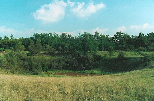
|
SINKHOLES IN
ISTRIA |
 |
 |
|
A vegetable patch between Trviž
(Terviso) and Beram/ (Vermo). |
A soccer field near Vizinada. |
A cenote is a partly
water-filled, wall-sided doline. It is formed by the collapse of
a cave which is (today, not necessarily at the time of the collapse)
filled with water. This sort of doline is very common in Yucatan,
México, where a large cave system with many entrances is filled with
water. The system was formed during the ice ages, when the surface of
the sea was 100 m lower than today. When the glaciers melted and the sea
level rose, the caves were filled with water. [Where are the
cenote in Istria?]
Foiba
A foiba (from Italian:
pronounced [ˈfɔiba];
plural: foibe
['fɔibe] or foibas) — jama (pronounced [ˈja̟mə])
in South Slavic languages scientific and colloquial vocabulary (borrowed
since early research in the Western Balkan Dinaric Alpine karst) — is a
type of deep natural sinkhole, doline, or sink, and is a collapsed
portion of bedrock above a void. Sinks may be a sheer vertical opening
into a cave, or a shallow depression of many hectares. They are common
in the Karst (Carso) region shared by Italy and Slovenia, as well as in
a karst of Dinaric Alps in Bosnia and Herzegovina, Montenegro and
Croatia. The foibe massacres, a war crime that took place during and
after the World War II, take their name from the foibe.
The Italian name "foiba" derives from Friulan "foibe",
which in turn derives from the Latin fŏvea meaning "pit" or
"chasm". The oldest document on which it is reported is an official
report in 1770, written by the Italian naturalist
Alberto Fortis, who
wrote a series of books on the Dalmatian karst.
They are chasms excavated by water erosion, have the shape of an
inverted funnel, and can be up to 200 metres (660 ft) deep. Such
formations number in the hundreds in Istria. In karst areas, a sinkhole,
sink, or doline is a closed depression draining underground. It can be
cylindrical, conical, bowl-shaped or dish-shaped. The diameter ranges
from a few to many hundreds of metres. The name "doline" comes from
dolina, the Slovenian word for this very common feature. The term
"foiba" may also refer to a deep wide chasm of a river at the place
where it goes underground.
Foiba is also the name of the well-known sinkhole that opens
near the castle of Montecuccoli, in
Pisino, and of the stream that flows
into it. The place plays a central role in
Jules Verne's novel
Mathias Sandorf.
Dry Valley
Valleys without a surface stream are
very common in karst areas. They were formed in two ways:
- In times before the water table was
too deep, the water drained on the surface.
- During the Ice Ages, the ground was
frozen for several meters below the surface. Summer was too short to
melt it this deep. But the frozen ground is water resistant, all
cracks are filled with ice. So the drainage happened on the
surface.
Karren - Lapies
- Limestone Pavements
Karren are minor forms of karst due
to solution of rock on the surface or underground. The name Karren is
German, originally it described this feature in the German and Austrian
Alps, where exist large karst areas with Karren.
Karren can be found on any kind of
surface. They are formed when water runs down a slope dissolving the
rock. Thus karren can be found on any soluble rock like limestone,
dolomite or gypsum. Karren always show how the water flows, they run
down the slope in the same path as the water. They get deeper and
deeper. Sometimes only thin limestone walls, a few centimeter thick,
remain.
Very similar
dissolution effects produce limestone pavements. They look very
similar to karren, but normally they are formed along a crack in the
limestone. In this case the water enters the crack and does not stay on
the surface. The dissolution continues inside the crack, which gets
wider and wider.
Large
limestone surfaces get cut into pavements. The number, position and
direction of the clefts depends on the cracks of the limestone. Often
the cracks, formed by tectonic forces, run in very few directions. Each
direction shows one stage in the tectonic history of the limestone.
Limestone with two main directions of cracks, with an angel of about 90°
in between, makes the typical limestone pavement which looks like an
enormous chess board.
Karst Lake
At first look, karst lakes look like
any other lake, but there often is something special with such lakes.
There may be no visible stream
flowing in, or none flowing out of the lake. Sometimes there is neither.
Those lakes tend to grow and shrink. The water level rises in spring,
when the snow melts or after heavy rains. The level falls in dry
periods. Some of those lakes disappear completely. Then they are called
seasonal lakes, as they only exist in some seasons.
The explanation of all this strange
behavour are caves. The lake is fed by springs below the water
level and emptied by swallow holes, also below the water level. Often
the same cave works as spring and swallow hole, depending on the season.
Another way to interpret this situation, is to say, the lake is a part
of the ground water. The surface of the lake is the water table. When
the water table in the hills around a depression rises above the ground
of the depression, it is filled with water. When the ground water
lowers, the lake dries up.
It is pretty difficult to decide, if
a lake is true karst lake. The geological examination is very difficult
and for some lakes the oppinions differ. Missing rivers in and out of
the lake, are visible on a map, and give a first hint. Not all seasonal
lakes are karst lakes but this is a second hint. And of course the
existence of karst around the lake is necessary.
Cerknisko Jezero in Slovenija is a
Karst Lake. [Was Čepić lake/lago d'Arsa a karst
lake?]
Karst Spring
A spring is a natural
resurgence of groundwater, usually along a hillside or from a valley
floor. Springs in karst areas differ from normal springs: they normally
have a much higher production, as they are just the end of a waterfilled
caves system. Also they are highly dependent on the weather. Every rain
and, of course, the snow melting leads to increasing production. Karst
springs regularly fall dry in dry periods in the summer! On the other
hand, the water quality is often poor! Both effects have the same
reason: the water flows rather fast through cave systems, there is not
enough time for micro organisms to clean the water. So karst springs are
not a good source for water supply.
An intermitting spring is a spring that
falls dry several times or most of the year. In most cases this
springs are situated above, but near to the groundwater table. As the
groundwater table moves inside the rock over the year, it sometimes
reaches the spring and the water starts to flow. As very wet years
often resulted in crop failure, the production of some wells were
counted as a bad omen. The Hungerbrunnen (famine well) in Germany is an
example.
[Where are the karst
springs in Istria?]
Losing Stream
A losing stream is one with a bed, which
allows water to flow directly into the groundwater system. A very famous
losing stream in Germany is the Danube. The Danube-spring is located in
the Schwarzwald (Black Forest), from where the Danube flows to the east.
Near Immendingen and again near Fridingen swallow holes in the bed of
the river make the river loose some water. In dry years, the Danube gets
completely dry and is reactivated several kilometers away by some
tributaries. The water reappears in the Aachtopf.
Natural Bridge or Tunnel
This term refers to a natural arch,
bridge or tunnel which is a void beneath still standing bedrock, usually
of short extent, and allowing human passage from one end to the other,
at least part of the time.
A natural arch is an arch of rock
formed by erosion (weathering). A natural bridge a bridge of rock
spanning a ravine or valley and formed by erosion. A tunnel is a
nearly horizontal cave open at both ends, fairly straight and uniform in
cross-section.
 |
| Veliki naravni most, a
natural bridge in the Rakov National Park near Postojna,
Slovenia. Photo by © Jochen Duckeck |
A natural bridge is somewhat shorter than
a tunnel. There are two different types of natural bridges/arches
depending on their formation. The following explanation focuses on the
second type of natural bridges:
- Natural bridges and arches - like in
Arches NP in USA - are formed by multiple erosive processes, like
fluvial erosion (flowing water, rivers), frost erosion and wind
erosion. They may be formed in not soluble rocks like basalt or
sandstone, but also in limestone.
- Natural bridges and tunnels in karst
areas are the ruins of caves.
In large cave systems collapses are very
common. Very often they result in domes that are optimal to stand the
pressure of the overlaying rocks. Sometimes the caves are large and very
near to the surface, so the ceilling gets too thin and collapses. As
erosion goes on, the collapsed rooms are widened to small valley with a
river, the former subterranean river. The valleys grow larger, the
connecting cave remains get shorter. Sometimes the remaining caves are
short enough, to see the other end and the next valley. This may be the
time to call them tunnel.
Examples of Natural Bridges:
- Veliki naravni most (photograph
above, right) in Rakov Škocjan Nature Reserve near Postojna,
Slovenia.
Polje (Karstic fields)
A polje is a large closed
depression draining underground, with a flat floor across which there
may be an intermittent or perennial stream. The polje may be liable to
flood and become a lake, and its floor makes a sharp break with parts of
surrounding slopes.
Polje is the Slovenian word for "field",
which means the flat and very fertile ground of the valleys in Slovenia.
In the area around Postojna many valleys show the same characteristics:
 |
| The end of the Rakov
Polje in Rakov National Park near Postonja, Slovenia. The river
flows down the narrow valley and enters a cave. It is possible to
visit the first part of the cave, but the rest is not even explored
by speleologists. Some divers explored only a short part of it, then
the river became too deep. Photograph © Jochen Duckeck. |
- The valleys are rather small, a few hundred meters wide and up
to one or two kilometers long.
- The sides of the valleys are rather steep.
- Most valleys have a stream flowing from one end to the other.
- The stream enters the valley in a karst spring, often the
entrance to a cave.
- The stream leaves the valley in a Ponor or the entrance to a
cave.
- And last but not least: the valley has a flat and very fertile
ground.
This typical form of a Polje is easy to
explain, when the way they were formed is clear. The karst area is
drained underground by caves. If the caves are rather near to the
surface and rather big too, sometimes the roof collapses and forms a
dolina. The stream tht flows through the cave now flows through the
Doline and [data missing].
Typical features of poljes are
their disappearing rivers. These usually emerge at the edge of a polje
and after flowing for some distance disappear into the ground again.
After heavy rain, normally occurring at the end of winter, the cavities
in the ground may not be able to absorb all the water immediately. This
then forms a lake, which may end by covering the whole area of the
polje. The peasants therefore always have their houses at the edges of a
polje, and if there is a heavy early rainfall in autumn must make haste
to get the harvest in before it is covered by the rising flood-water.
The passing summer tourist may be surprised to see small boats lying
about among dry cornfields; but these serve a useful purpose when the
poljes quickly turn into lakes after heavy rain.
A peculiarity of karstic country is the
absence of rivers of any length. Along the whole length of the Croatian
Adriatic coast only a few above-ground rivers of any size reach the sea
- the Dragonja, Mirna and Raša in Istria, the Krka and Čikola at
Šibenik, the Cetina at Omi and the Neretva in the Opuzen delta. The
water which seeps into the ground re-emerges at the foot of the hills in
the form of large karstic springs.
In the extensive karstic region large
numbers of caves have been formed by the erosion of water-soluble rock.
The total number of caves can only be estimated, but is certainly over
10,000. In Slovenia alone - where the exploration of caves has been most
actively pursued - there are more than 3,500, mostly in Triassic,
Jurassic and Cretaceous limestones.
Tower Karst - Cockpit Karst - Cone Karst
| English: |
Tower karst |
cockpit
karst; conical karst; kegel karst; polygonal karst |
| German: |
Turmkarst
(r) |
Kegelkarst
(r) |
| Spanish: |
Karst de
torres |
kárst
cónico (m) |
| Hungarian: |
Toronykarszt |
kúpkarszt |
| Italian: |
Carso (sm)
a torri |
carso (sm)
a coni; carso (sm) poligonale |
| Portuguese: |
Carste em
torre |
cárste
cônico |
| Romanian: |
Carst (n)
de turnuri |
carst (n)
conic |
This category has a spectacular variety
of karst landscape, dominated by steep or vertical sided limestone
towers (karst towers) or cones. The towers originate as
residual cones and are then steepened by water table undercutting from
surrounding alluviated plains.
Tower karst,
cone karst and cockpit karst are different but rather similar
forms of this kind of landscape. There are two different explanations
for this kind of landscape, both explaining a certain aspect of the
geology. In reality, it seems to be a combination of both:
- Tower Karst is typically interpreted
as a karst area in a very late stage of development. To
explain this we first need a sort of chronology of karst
development:
- Limestone reaches the surface and
gets subject to weathering.
- Ground water starts with the
solution of limestone and forms first caves. A lower drainage
system around the limestone area is necessary for the secons
stage: the rivers and lakes leave the surface, drainage of the
whole area is underground. This is the "typical" stage of a
karst area, which we know well from moderate climate zones.
- The limestone caves get bigger and
bigger and start to collapse. Cave systems are marked at the
surface by daisy chains of dolines. Dolines merge and form
poljes.
- The cave systems are more or less
collapsed. The former poljes grew and grew until they are all
connected and again form a net of subaerial valles draining the
area. The former limestone plateau is cut into isolated
limestone islands.
- The formation of the towers is a
combination of tectonic uplift and tropical karst erosion. Tectonic
uplift matched by karst erosion increases tower heights, as the
solution is bigger in the valleys. If uplift is too slow, the towers
are dissoluted and shrink, if it exceeds erosional surface lowering,
the towers are raised to hillside locations and the landscape is
rejuvenated to form a new generation of dolines and cone karst.
Cone and tower karst exist only in sub
tropic and tropic climate zones. Both typically exist in in areas with
tectonic uplift. In many areas the towers are full of inactive caves at
(multiple) higher levels, and with active caves through their bases.
There may be alluvial plains between the towers and flat-floored
depressions within them.
- Cockpit karst is the beginning of the development. After
cave systems developed, grew and collapsed, the former caves form
huge valleys and the limestone inbetween remains as hills.
- Cone karst is the more common and less spectacular form of
this landscapes with steep limestone hills, residual cones,
typically covered by rain forest.
- Tower karst is the spectacular form with 30-300m high
towers with vertical or overhanging sides. The walls are typically
bare rock, as the walls are too steep for vegetation.
Tower karst occurs throughout southeast
Asia. By far the most extensive and best developed tower karst is in the
Guangxi province
of southern China. This is the ultimate development of tower karst,
in which the residual hills have very steep to overhanging slopes. Other
famous areas of tower karst are Vietnam, Thailand and Malaysia. Cone
karst occurs in Cuba, Madagaskar and Puerto Rico.
Very common is
submerged tower karst on the coast of Thailand and in the Chinese Sea.
The towers form steep limestone islands in the sea, sometimes with
donlines inside that form salt water lakes with steep walls. This
spectacular landscape was used as location for many movies. Most famous
examples are (per IMDB):
-
James Bond movies -
- The Beach with Leonardo DiCaprio -
https://us.imdb.com/Title?0163978
Karst Caves
A cave is an airfilled underground void,
large enough to be examined in some way by man. While there are caves in
other kinds of rock besides limestone, dolomite and gypsum, they do not
have karst features and therefore are not karstic caves.
[expand]
Typical features of karst areas are:
- No water on the surface, water
oozes away and flows in subterranean rivers.
- Large springs, often with rapidly
changing amout of water, depending on the weather.
- Dolines or sinkholes.
- Karst lakes which have no connection
to rivers on the surface.
- Dry valleys which were formed when the
rivers were still on the surface, before the karst developed.
Speleothems - Karstic Cave Formations
[expand]
The term dripstone is applied to a
variety of different formations:
Water dripping from the roof of a cavern
may form calcium "icicles" or stalactites, or it may build up
stalagmites
on the floor of the cavern. When stalactites hanging from the roof join
up with stalagmites growing upward from the floor and then increase in
thickness they form columns known as stalagnates.
Another type of formation which creates a
particularly striking effect in illuminated caverns consists of the
sinter curtains formed by water trickling from an overhanging rock
face. This can produce canopy-like formations. like those to be seen in
the Postojna caves.
The shape taken by the dripstone
formations depends on a variety of factors, including the calcium
content of the water, the amount of evaporation in the cavern and the
direction of air movement. They are given their colouring by traces of
metallic salts dissolved in the water.
The formations in caves which have been
open to the public for a century or more often lack the brilliance of
colour found in more recently discovered caves. This is because in the
past the caves were frequently illuminated by torches, bundles of
burning straw or oil lamps, and soot deposits have dulled the colours.
[insert a story or
two about lights]
Not infrequently the roof of an
underground cavern will fall in, producing a depression like a bomb
crater, known as a doline (sink,
swallowhole), which may sometimes reach a diameter of as much as 1100
yd/1000 m. Adjoining dolines occasionally coalesce, forming what is
known as an uvala. Stili larger depressions, sometimes covering
many square miles and usually surrounded by hills, are known as
poljes
("fields") .
Dolines usually provide good agricultural
land, since fertile alluvial soil tends to accumulate in them. Poljes
with a flat floor, making them particularly suitable for agricultural
use, commonly acquire a cover of reddish clay-like soil (terra rossa)
deposited by the percolating water.
Examples of Karstic Areas and Caves
The most famous complex of caves is the
Postojna Caves (Postoinska Jama) in present-day Slovenia
along the subterranean course of the River Pivka, with a number of
connected caves, the Otoška Jama,
Crna Jama, Magdalenska Jama and Pivka Jama. After
pursuing a course which has not yet been traced the Pivka reappears in
the Planinska Jama, where it is joined by the River Rak, which
has also followed an underground course, passing through the Zadnja
Jama and Tkalca Jama (Weaver's Cave). To the east of Postojna
is the beautiful Kiržna Jama. (See list of show caves in Slovenia
at https://www.showcaves.com/english/si/Showcaves.html.)
The Triestine and Dinarian Karst in
Italy and Slovenia are, in fact, only one karst area - a large limestone
plateau divided into two parts by the political border. The caves in
Slovenija and the caves in Italy are connected. Around Trieste are the
Škocjan Caves which belong to the Reka-Rimavo river system. These
caves are traversed by the River Reka, with a number of other caves
branching off them. Two notable caves in this region are Grotta
Gigante and San Giovanni d'Antro. Southwest of Divača are the
Divaška Jama
and Vilenica Jama (Fairy Cave), still explored, and to the
Southeast is the
Dimnice Jama
(Cave of Mist).
In Croatian Istrian, the town of
Pazin is
situated on the rim of a gorge (the foiba of
Pazin), into which the
little River Pazinski Potok disappears and which is a typical karstic
feature. This tremendous hole in the ground, Pazinska Jama, is
said to have inspired
Dante's vision of the entrance to the Inferno in
his Divine
Comedy. Both the subterranean caverns and the castle in
Pazin,
now housing the Ethnographic Museum, are described by
Jules Verne in
his novel,
Mathias Sandorf.
A well-known karstic cave of recent discovery is
Baredine Jama,
near Poreč.
The most famous cave in Lower Carniola is
the Taborska Jama (Tabor Cave), with the Ledenica Jama as
an antechamber.
An impressive example of karstic
landscape can also be seen near Dubrovnik. In the neighbourhood of the
little Moslem town of Trebinje is the Popovo Polje, more than 35
miles/60 km long, which fills up with water every September.
Sources:
- Baedeker's Yugoslavia,
translated from the German original, Prentice Hall Press, printed in
Great Britain by Jarrold & Sons. Ltd. (Norwich, c. 1987), p. 99-101,
229, 262.
- A Karst Primer -
https://www.umsl.edu/~joellaws/ozark_caving/mss/karst.htm
-
Show Caves of the World, Karst -
https://www.showcaves.com/english/explain/Karst/Karst.html
- Photographs of Sinkholes in Istria -
Mirko Gabler.
|